
Floods are very serious and deadly environmental phenomena. They can have devastating effects on buildings, infrastructure, personal property, agriculture, natural wildlife habitat, and more. Mostly everywhere in the world that receives rain is susceptible to flooding, but particularly densely populated areas, areas in close proximity to rivers or the coast, and areas low in elevation. Densely populated areas such as cities have minimal trees and soil to absorb the water. Instead, it flows off of rooftops, streets, parking lots, etc., and into storm drains, then bodies of water. In severe instances, the storm drains and pipes become full, which can result in much more damage to the surrounding area. It can be caused by heavy rains or hurricanes, large ocean waves, rapid snow melt, or in the event of a dam or levee breaking. They become particularly bad when the ground becomes saturated and is unable to absorb more water, and flash floods occurring at a rapid pace can be the most dangerous as people have a limited amount of time to get to safety. According to the NOAA, floods kill more people each year than hurricanes, tornadoes, or lightning.
The Schuylkill watershed, and the Schuylkill river specifically, is no exception and has been enduring floods for as long as the records show, the earliest recorded dating back to the 1700's. According to the NOAA's Schuylkill River gauge located in Philadelphia, the water level is normally around 6-7 feet. The following graph depicts this data.
This screenshot was taken on Sunday, September 24th, 2023. It has been raining since Friday, and still the water levels are not close to action level at 10 feet, minor flooding level at 11 feet, moderate flooding level at 13 feet, or major flooding at 15.5 feet. This goes to show that it takes an exceptional amount of rain to lead to flooding conditions, with around a 5% chance of exceeding the 11 feet minor flooding threshold over the next month and a 2% chance of reaching the moderate flooding threshold of 13 feet. The following graph shows likelihood of different flood levels occurring.
The all time record flood is listed at 17 feet. While that record was set in 1869, the record was nearly broken just two years ago in September of 2021 with a flood measuring in at 16.3 feet as a result of Hurricane Ida. Here is the full list of the top 30 flooding events on record:
This data reveals that in the last 30 years (since 1993), 22 of the 30 largest floods of all time at this location have occurred. I speculated that there may be a high portion occurring in recent decades considering climate change, but to have such a high ratio is quite the harrowing realization. Considering this data goes back to at least 1869, and weather.gov has data going back to 1769, the fact that from that ~150-250 year period, 22 out of 30 of the largest floods have come in the last only 30 years is a clear indicator that weather patterns and the water cycle are changing.
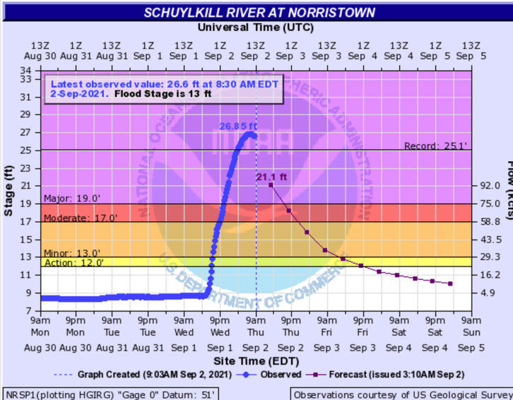
To get back to the 2021 flood, this was a flood I experienced first hand. Going over the Conshohocken bridge and seeing the height of the water first hand blew my mind. My friends apartment in Manayunk got flooded. Many restaurants and businesses were forced to close, exacerbated by the fact that Covid was still a prominent issue. The Vine Street Expressway, an extra low highway going through the city was totally flooded with water reaching the bottom of bridges and the traffic signs. See image at the top of this post. The Norristown gauge, which is a few miles up the river from Philadelphia, actually did set a record at 26.85 feet, with the previous record being 25.1 feet. The Norristown Schuylkill gauge graph from that day can be seen below.

In recent months, 2 years after the flood, estimates have been released as to the extent of the damage. Philly Inquirer estimates 11,000 homes were damaged. WHYY reports the city received $163 million in federal aid as a result. This flood, brought about by Hurricane Ida, was disastrous and unfortunately it seems as though events like this have become more common as climate change continues. More and more carbon enters our atmosphere, ocean temperatures rise, and hurricanes become more common and powerful. Hopefully we can learn some lessons from this recent flood and become more prepared moving forward because it does not seem like they will stop anytime soon.
References:
1. https://whyy.org/articles/hurricane-ida-philadelphia-flooding-recovery-money-home-repairs/:~:text=FEMA%20verified%20that%20nearly%2011,000,sits%20upwards%20of%20$810%20million.
2. https://www.inquirer.com/science/climate/hurricane-ida-philadelphia-block-grant-hud-20230810.html
3. https://6abc.com/philadelphia-flooding-vine-street-expressway-hurricane-ida-schuylkill-river/10994172/
4. https://patch.com/pennsylvania/norristown/schuylkill-river-floods-all-time-record-height-norristown#:~:text=The%20flooding%20was%20historic%20across,hits%2019%20feet%20in%20Norristown.
5. https://www.nssl.noaa.gov/education/svrwx101/floods/
6. https://www.weather.gov/media/marfc/FloodClimo/SEPA/Philadelphia.pdf
7. https://water.weather.gov/ahps2/hydrograph.php?wfo=phi&gage=padp1&hydro_type=2


No comments:
Post a Comment